This section summarizes the results of the City of New Orleans and other stakeholder efforts to develop policies, programs, and activities that directly or indirectly support hazard mitigation. It also provides information on resources and gaps in the parish’s infrastructure, as well as highlighting major changes in its capabilities since the last plan update. The City of New Orleans capabilities is unique to the parish, including planning, regulatory, administrative, technical, financial, and education and outreach resources. Through this assessment, New Orleans is able to identify strengths that could be used to reduce losses and reduce risk throughout the community. It also identifies areas where new actions to reduce risk might supplement current capabilities and create a more resilient community before, during, and after a hazard event.
Policies, Plans, and Programs
There are a number of mitigation-related acts, plans, executive orders, and policies that lay out specific goals, objectives, and policy statements that already support or could support pre-and post-disaster hazard mitigation. Many of the ongoing plans and policies hold significant promise for hazard mitigation and take an integrated and strategic look holistically at hazard mitigation in New Orleans to propose ways to continually improve it. These tools are valuable instruments in pre-and post-disaster mitigation as they facilitate the implementation of mitigation activities through the current legal and regulatory framework.
Master Plan
The Plan for the 21st Century, commonly referred to as the Master Plan, is a City Charter-mandated planning framework for the core systems that shape New Orleans’ physical, social, environmental, and economic future. The Plan for the 21st Century reflects the values and priorities that emerged through a community participation process and is grounded in information assembled for the first time in one place. In 2010, the Plan was unanimously adopted by both the City Planning Commission and the City Council and was signed by Mayor Mitchell Landrieu. The City engaged in a City Charter mandated Master Plan amendment process from 2016 to 2018.
The Master Plan includes specific vision items such as livability, opportunity, sustainability, equity, and resilience. Chapter 12 of the Master Plan is titled “Adapt To Thrive: Environmental Stewardship, Disaster Risk Reduction, And Climate Change.” This section includes specific goals and implementation strategies for a host of challenges facing the New Orleans region moving forward and is directly related to many of the topics discussed in the Hazard Mitigation Plan. Topics like coastal protection and restoration, regional government and agency collaboration, urban stormwater management, pre-disaster planning and post-disaster recovery, hazard mitigation planning, community resilience, brownfield remediation, and community outreach and education are defined and discussed in Chapter 12. The Master Plan recommends specific action for each goal and then assigns responsible agencies the proposed timeline and necessary resources to achieve the goals.
The Plan for the 21st Century serves as a valuable tool for the City of New Orleans, its partners, and residents. Significant effort went into the creation of the plan, and the plan is a reflection of community vision and goals due to the level of public outreach and collaboration that went into the effort.
The Comprehensive Zoning Ordinance (CZO)
The CZO is the law that governs land use throughout the City of New Orleans. The CZO includes lists of permitted land uses for each of the City’s zoning districts, in addition to height limits, setback requirements, urban design standards, operational rules, and other regulations. The CZO is broken into a series of Articles that cover citywide standards, individual zoning district regulations, and the processes for variances, conditional use permits, and other land use reviews.
The principal goals of the CZO are to encourage and promote, in accordance with present and future needs, the public health, safety, and welfare of the citizens of the City of New Orleans and to ensure that the policies set forth in City's Master Plan are implemented by the land use regulations and are consistent with the goals set forth in the Master Plan. The CZO includes numerous requirements for topics related to the sustainability and resilience goals of the Hazard Mitigation Plan.
Requirements for minimum permeable open space and maximum impervious surfaces on lots vary throughout the city based on the existing development pattern and uses and are intended to reduce excessive paving and related flooding. Article 23 of the CZO includes landscaping requirements for new development and ensure that sufficient landscaping is provided in order to reduce flooding and improve air quality and public health. Article 22 regulates parking and requires permeable pavement for parking spaces, and sets a maximum number of parking spaces allowed in order to reduce flooding and the overreliance on the automobile as a primary means of transportation. The CZO also includes requirements and incentives for affordable housing so that residents can live safely and comfortably within Orleans Parish in a manner that will afford them and their families the right to be better prepared for potential disasters. Additionally, the CZO defines and regulates Open Space Districts in order to provide residents with access to active and passive recreation areas and preserve national resources within the wetlands and coastal areas.
City Assisted Evacuation Plan (CAEP)
The CAEP provides for the needs of the residents of New Orleans in the event an evacuation is required. This plan includes a Special Needs Registry for those residents that require special assistance during an evacuation.
Other Plans
- Resilient NOLA – A plan that sets forth how the city can adapt to face challenges in the wake of Climate Change in an equitable manner.
- Climate Action for a Resilient New Orleans – This plan centers on addressing energy use, transportation options, waste reduction, and creating a culture of awareness and action.
- Taking Steps Together On Equity & Climate Change: A Report By And For New Orleanians – This report goes a step further to implement and operationalize the climate action plan created by the city of New Orleans while ensuring equity in the face of climate change.
Table 52: City of New Orleans Planning and Regulatory Capabilities
| |
City of New Orleans |
Comments |
| Plans |
Yes / No |
|
| Comprehensive / Master Plan |
Yes |
|
| Capital Improvements Plan |
Yes |
|
| Economic Development Plan |
No |
|
| Local Emergency Operations Plan |
Yes |
Includes many event and hazard-specific plans. |
| Continuity of Operations Plan |
No |
|
| Transportation Plan |
Yes |
|
| Stormwater Management Plan |
Yes |
|
| Community Wildfire Protection Plan |
No |
|
| Other plans (redevelopment, recovery, coastal zone management) |
Yes |
|
| Building Code, Permitting and Inspections |
Yes / No |
|
| Building Code |
Yes |
2015 International Building Code |
| Building Code Effectiveness Grading Schedule (BCEGS) Score |
No |
Work in Progress |
| Fire Department ISO/PIAL rating |
Yes |
|
| Site plan review requirements |
Yes |
|
| Land Use Planning and Ordinances |
Yes / No |
|
| Zoning Ordinance |
Yes |
|
| Subdivision Ordinance |
Yes |
Under Revision: Due Mid-2020 |
| Floodplain Ordinance |
Yes |
|
| Natural Hazard Specific Ordinance (stormwater, steep slope, wildfire) |
Yes |
Stormwater Ordinance |
| Flood Insurance Rate Maps |
Yes |
New maps adopted 2016 |
| Acquisition of land for open space and public recreation uses |
No |
|
| Other |
No |
|
Source: FEMA Capability Assessment Worksheet 4.1
Building Codes, Permitting, Land Use Planning and Ordinances
The City of New Orleans provides oversight for building permits and codes, land use planning, and all parish ordinances. The NOHSEP, through this Hazard Mitigation Plan, coordinates between city agencies and external partners to maintain the mitigation plan and implement mitigation actions.
As of the 2020 update, The City of New Orleans and its jurisdictions ensure that all adopted building codes are enforced and in compliance relating to the construction of any structure within the boundaries of the parish. Building permits are required prior to beginning any type of construction or renovation projects, installation of electrical wiring, plumbing or gas piping, moving manufactured/modular or portable buildings, and reroofing or demolitions.
The City of New Orleans Office of Safety and Permits is the agency primarily charged with enforcing the ordinances related to health and safety, property maintenance standards, and condemnation of unsafe structures.
The City’s participation in the National Flood Insurance Program and Community Rating System is coordinated through the Office of Safety and Permits. Because of the complexity of these programs and their importance to mitigating flood risk and making affordable flood insurance available to the city’s residents, these programs are detailed in a separate section below.
The City of New Orleans Council meets regularly to consider any proposed ordinance changes and to take final actions on proposed changes.
Some programs and policies, such as the above described, might use complimentary tools to achieve a common end but fail to coordinate with or support each other. Thus, coordination among local mitigation policies and programs is essential to hazard mitigation.
Administration and Technical Capabilities
As a community, New Orleans has administrative and technical capabilities in place that may be utilized in reducing hazard impacts or implementing hazard mitigation activities. Such capabilities include staff, skillset, and tools available in the community that may be accessed to implement mitigation activities and to effectively coordinate resources. The ability to access and coordinate these resources is also essential. Table 53 shows examples of resources in place in New Orleans.
Table 53: City of New Orleans Administration and Technical Capabilities
| |
City of New Orleans |
Comments |
| Administration |
Yes / No |
|
| Planning Commission |
Yes |
|
| Mitigation Planning Committee |
Yes |
|
| Maintenance programs to reduce risk (tree trimming, clearing drainage systems) |
Yes |
|
| Mutual Aid Agreements |
Yes |
|
| Staff |
Yes / No |
|
| Chief Building Official |
Yes |
ICC Certified Building Official |
| Floodplain Administrator |
Yes |
ASFPM Certified Floodplain Manager |
| Emergency Manager |
Yes |
|
| Community Planner |
Yes |
Director of City Planning Commission |
| Civil Engineer |
Yes |
|
| GIS Coordinator |
Yes |
|
| Grant Writer |
Yes |
|
| Other |
Yes |
VOAD (See Below) |
| Technical |
Yes / No |
|
Warning Systems / Service
(Reverse 911, outdoor warning signals) |
Yes |
|
| Hazard Data & Information |
Yes |
Automated Flood Warning System, installed in 2019 |
| Grant Writing |
Yes |
|
| HAZUS Analysis |
Yes |
|
| Other |
|
|
Source: FEMA Capability Assessment Worksheet 4.1
Automated Flood Warning System (AFWS)
In August 2019 NOHSEP installed a system of sensors and automated alerts at 12 frequently flooded roadway underpasses. The sites measure rainfall and water level and provide on-site warnings to motorists, and also transmit data to city emergency managers. The city has established real-time data sharing with SWBNO and NWS to help coordinate situational awareness and emergency response.
Figure 51: Automated Flood Warning System on Marconi Drive
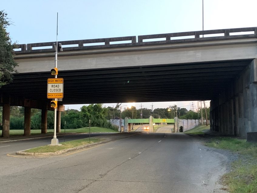
Source: New Orleans Office of Homeland Security and Emergency Preparedness
Voluntary Organizations Active in Disaster (VOAD)
The New Orleans Office of Homeland Security & Emergency Preparedness hired a staff member in 2019 to be the liaison and coordinator between the voluntary organizations active in disaster (VOAD) and the City of New Orleans. VOADs are critical partners when it comes to disaster recovery, as they often pick up where government response ends and handle a lot of the services and needs that are not covered by local emergency management or federal disaster aid. By investing energy, staff time, and resources into cultivating a highly responsive and effective VOAD, NOHSEP sought to enhance preparedness and coordination around disaster response and recovery and bring more resources to support residents during and following a disaster. Extensive effort was put into outreach and engagement to support the creation of a local New Orleans VOAD and build key relationships with state and national disaster response non-profits able to deploy if needed.
NOHSEP is currently finalizing a VOAD and Donations Plan to add to the Comprehensive Emergency Operations Plan update for 2020.
Some highlights from 2019 and 2020:
- The number and diversity of VOAD groups working directly with the City of New Orleans to offer disaster response and recovery services increased, with coordination calls often having anywhere from 30-50 organizational partners participating. The New Orleans VOAD includes non-profits and faith organizations at the local, state, and national levels.
- Via the VOAD partners, the City was able to access and provide residents with an extensive range of disaster recovery capabilities, such as:
- Mucking & gutting
- Debris removal
- Rebuilding
- Case Management
- Legal Aid
- Feeding Operations
- Donations Management
- Volunteer Coordination
- Functional and Access Needs Support & Advocacy
- Health
- Children services
- NOHSEP hosted the first Hurricane Table Top Exercise with over 50 VOAD partners in May 2019
- NOHSEP activated the New Orleans VOAD for 8 emergency activations, including Hurricane Barry, Hard Rock Collapse, COVID19 Pandemic, Hurricane Cristobal, Hurricane Marco/Laura, Hurricane Laura Evacuee Support, Hurricane Sally, and Hurricane Delta.
- NOHSEP hosted regular VOAD coordination calls through emergency activations. These calls have improved information sharing between the City of New Orleans and VOAD partners, allowed for continual assessment of capabilities of organizations to inform response and recovery operations, and improved communication and coordination between VOAD, as well as key functional and access, needs agencies and vulnerable communities.
- In partnership with key VOAD partners, NOHSEP has set up a more formal relationship with both Second Harvest Food Bank and World Central Kitchen to provide feeding support to City-run emergency sheltering operations with water, snacks, and meals. Second Harvest Food Bank and World Central Kitchen have either been on standby or have provided feeding support for City emergency sheltering operations for multiple emergency activations and storm shelters. This is a new development, as previous to VOAD outreach in 2019, the City depended on either MRE's or donations to support smaller-scale feeding operations at the shelters.
- VOAD members assisted in the Hard Rock Hotel Collapse response via volunteering to assist with feeding efforts of First Responders. VOAD organizations like Second Harvest Food Bank and the Salvation Army provided daily meal delivery and donated items to Hard Rock collapse evacuees at different hotels.
- Through NOHSEP coordination, VOAD partners mobilized rapidly and extensively to assist with key food security issues and the feeding of vulnerable populations through the COVID-19 pandemic. This effort later lead to the creation of a Food Security Task-force with VOAD partners and City agencies. VOAD partners, such as World Central Kitchen and Second Harvest Food Bank, provided millions of meals and food boxes to residents in need throughout the pandemic.
- The engagement of National VOAD partners such as Americares and the GOA Foundation resulted in the donation of hundreds of thousands of critical PPE (N95's, KN95's, surgical masks, face shields, hand sanitizer, etc.) to NOHSEP during the COVID-19 pandemic. This PPE was distributed to public safety agencies, health partners, as well as local VOAD partners. The N95's were also stored for use for residents in the event of a City Assisted evacuation due to a major hurricane.
- Through coordination and strong relationships with VOAD partners, NOHSEP was able to track volunteer hours and donations to support our cost share with FEMA.
- VOAD partners like Air BnB provided free COVID-19 housing to First Responders and Essential Workers who needed to isolate from their families due to their high exposure jobs. VOAD partners like UBER have been helpful in providing free transportation resources to Hard Rock Collapse impacted residents, as well as Hurricane Laura evacuees.
- Extensive VOAD participation assisted in supporting the over 12,000 Hurricane Laura evacuees in New Orleans. VOAD partners such as Catholic Charities, United Way, LA SPCA, the Junior League, Hands On New Orleans, Save the Children, and Southeast Louisiana Legal Services worked with the City to provide donations for evacuees, to receive and sort an extensive donations collection for the City of New Orleans Evacuee Resource Center, and to provide key services and referrals at the Resource Center.
- VOAD members have assisted with the City of New Orleans City Assisted Evacuation program, with some serving as Evacuspot Site Leaders at critical locations in the Lower Ninth ward, Central City, Bywater, New Orleans East, and Lakeview. The ability to use VOAD members as Evacuspot leaders is helpful to NOHSEP as they are volunteers who have leadership skills, know how to coordinate other volunteers, and can be depended on to show up in a hurricane evacuation. NOHSEP also continues to have key conversations with UBER and Lyft on ways their operations can support vulnerable residents to get to their neighborhood Evacuspot in the event of a City Assisted Evacuation.
- VOAD partners have been key players in disseminating NOLA Ready emergency information and supplies to vulnerable communities through their agencies and the communities they serve. VOAD partners have distributed hurricane preparedness brochures and also masks at food distributions, senior centers, churches, and to the undocumented immigrant community. VOAD partners also helped the City of New Orleans promote the COVID19 Meal Assistance Program, share COVID19 testing information, share City Assisted Evacuation information, and much more.
- VOAD partners have both promoted and assisted with NOLA Ready volunteer trainings, taking a particularly active role in CERT trainings. Lighthouse Louisiana has shared a Blind and Deaf Sensitivity training with NOLA Ready CERT volunteers, as well as the Medical Reserve Corps volunteers. NOLA Tree Project gave a Flood Response and Muck & Gut Training for both CERT participants, houses of worship, and NOLA Ready Corp volunteers.
Financial Capabilities
Financial capabilities are the resources that New Orleans has access to or is eligible to use in order to fund mitigation actions. Costs associated with implementing the actions identified by the parish may vary from little to no cost actions, such as outreach efforts, or substantial action costs such as the acquisition of flood-prone properties. The following financial resources are available to fund mitigation actions in New Orleans:
Table 54: City of New Orleans Financial Capabilities
| |
City of New Orleans |
Comments |
| Funding Resources |
Yes / No |
|
| Capital Improvements project funding |
Yes |
|
| Authority to levy taxes for specific purposes |
Yes |
|
| Fees for water, sewer, gas, or electric services |
Yes |
|
| Impact fees for new development |
Yes |
|
| Stormwater Utility Fee |
Yes |
|
| Community Development Block Grant (CDBG) |
Yes |
|
| Other Funding Programs |
Yes |
|
Source: FEMA Capability Assessment Worksheet 4.1
Education and Outreach
A key element in hazard mitigation is promoting a safer, more disaster-resilient community through education and outreach activities and/or programs. Successful outreach programs provide data and information that improves the overall quality and accuracy of important information for citizens to feel better prepared and educated with mitigation activities. These programs enable the individual communities and the parish as a whole to maximize opportunities for the implementation of activities through greater acceptance and consensus of the community.
New Orleans has existing education and outreach programs to implement mitigation activities, as well as communicate risk and hazard-related information to its communities. Specifically, focusing on advising repetitive loss property owners of ways they can reduce their exposure to damage by repetitive flooding remains a priority for the entire parish. The existing programs are as follows:
Table 55: City of New Orleans Education and Outreach Capabilities
| |
City of New Orleans |
Comments |
| Program / Organization |
Yes / No |
|
| Local citizen groups or non-profit organizations focused on environmental protection, emergency preparedness, access, and functional needs populations, etc. |
Yes |
VOAD work in the community |
| Ongoing public education or information program (responsible water use, fire safety, household preparedness, environmental education) |
Yes |
NOLA Ready for Public Information and emergency warning |
| Natural Disaster or safety-related school program |
Yes |
|
| Storm Ready certification |
Yes |
|
| Firewise Communities certification |
No |
|
| Public/Private partnership initiatives addressing disaster-related issues |
Yes |
VOAD |
| Other |
Yes |
Sheltering and Evacuation (See Below) |
Source: FEMA Capability Assessment Worksheet 4.1
Sheltering
The city is involved in sheltering efforts beyond freeze shelter situations. The city has provided shelter with the use of MCCNO after Hurricane Isaac for an MSNS shelter and the New Orleans East tornado shelter at Joe Brown Park.
Evacuation
City-assisted evacuation and seeks to mitigate the impacts on human health while addressing the lack of transportation or medical/mobility needs within the city via a special needs registry and with Evacuspots, which are designated areas throughout the city for people to gather for evacuations assistance.
The communities within New Orleans rely on the New Orleans Office of Homeland Security and Emergency Preparedness (NOHSEP) and/or City of New Orleans Government agencies for the above-listed planning and regulatory, administrative and technical, financial, and education and outreach capabilities. As reflected in the above existing regulatory mechanisms, programs, and resources within the parish, New Orleans remains committed to expanding and improving on the existing capabilities within the parish. Communities, along with New Orleans, will work together toward increased participation in funding opportunities and available mitigation programs. Should funding become available, the hiring of additional personnel to dedicate to hazard mitigation initiatives and programs, as well as increasing ordinances within the parish, will all enhance and expand risk reduction for all of Orleans Parish.
Flood Insurance and Community Rating System
National Flood Insurance Program
Flood insurance data provided by FEMA indicate that New Orleans has 75,653 flood insurance policies with the NFIP, with total annual premiums of $53,614,489. The City of New Orleans will continue to adopt and enforce floodplain management requirements, including regulating new construction in Special Flood Hazard Areas, and will continue to monitor activities, including local requests for new map updates. Flood insurance statistics and additional NFIP participation details for Orleans Parish are provided in the tables to follow.
The City of New Orleans will continue active participation in the NFIP through various education and outreach activities. These activities will include community outreach on the availability of flood insurance within the parish, as well as flood safe building initiatives throughout the parish. The Parish Floodplain Manager will continue to work to ensure floodplain management regulations are adopted and enforced. The Parish Floodplain Manager will continue to seek and attend floodplain management and NFIP continuing education.
Table 56: Summary of NFIP Policies for Orleans Parish as of 8/31/2019
| Jurisdiction |
No. of Insured Structures |
Annual Premium Paid |
No. of Insurance Claims Filed Since 1978 |
Total Loss Payments |
| Orleans Parish |
75,653 |
$53,614,489 |
124,290 |
$7,284,016,275 |
The new FIRM adopted in 2016 reduced the overall extent of special flood hazard areas across the city. As individual properties were removed from the SFHA, they were no longer required to carry flood insurance as a condition of carrying a federally-insured mortgage. Likely as a result, the number of properties with active flood insurance policies shrank in the immediate following years (Figure 51). The continued drop in flood insurance policies likely reflects the increasing cost of insurance premiums and broader economic circumstances that affect the affordability of insurance.
Figure 52: Flood Insurance Coverage, Orleans Parish
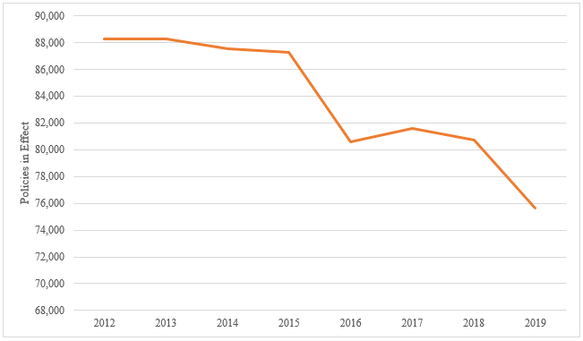
Source: City of New Orleans
Repetitive Loss Properties
Repetitive loss structures are structures covered by a contract for flood insurance made available under the NFIP that:
- a. Have incurred flood-related damage on two occasions, in which the cost of the repair, on average, equaled or exceeded 25 percent of the market value of the structure at the time of each such flood event; and
- b. At the time of the second incidence of flood-related damage, the contract for flood insurance contains the increased cost of compliance coverage.
Severe repetitive loss (SRL) is defined by the Flood Insurance Reform Act of 2004 and updated in the Biggert Waters Flood Insurance Reform Act of 2012. For a property to be designated SRL, the following criteria must be met:
- a. It is covered under a contract for flood insurance made available under the NFIP; and
- b. It has incurred flood-related damage –
- 1) For which four or more separate claims payments have been made under flood insurance coverage with the amount of each claim exceeding $5,000 and with the cumulative amount of such claims payments exceeding $20,000; or
- 2) For which at least two separate claims payments have been made under such coverage, with the cumulative amount of such claims exceeding the market value of the insured structure.
Figures regarding repetitive loss structures for Orleans Parish are provided in the table below:
Table 56: Repetitive Loss Structures for Orleans Parish
| Jurisdiction |
Number of Structures |
Residential |
Commercial |
Total Claims |
Total Claims Paid |
Average Claim Paid |
| Orleans Parish |
8,363 |
7,619 |
747 |
28866 |
$1,131,207,823 |
$135,214 |
Figure 53: Repetitive Loss Property Densities in Orleans Parish
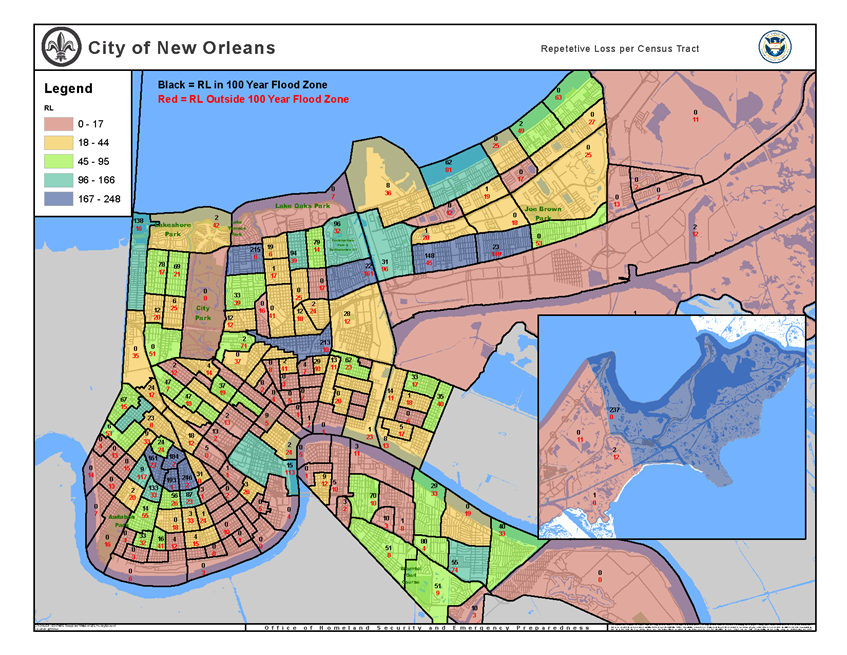
Source: City of New Orleans Repetitive Loss List 8/19
New Orleans is currently participating in the Community Rating System (CRS). Participation in the CRS strengthens local capabilities by lowering flood insurance premiums for jurisdictions that exceed NFIP minimum requirements. If you wish to see a map of NFIP communities around Louisiana, please visit the linked FEMA website in the footnote.[1]
The Federal Emergency Management Agency’s National Flood Insurance Program (NFIP) administers the Community Rating System (CRS). Under the CRS, flood insurance premiums for properties in participating communities are reduced to reflect the flood protection activities that are being implemented. This program can have a significant influence on the design and implementation of flood mitigation activities, so a brief summary is provided here.
A community receives a CRS classification based upon the credit points it receives for its activities. It can undertake any mix of activities that reduce flood losses through better mapping, regulations, public information, flood damage reduction, and/or flood warning and preparedness programs.
There are ten CRS classes: class 1 requires the most credit points and gives the largest premium reduction; class 10 receives no premium reduction (see Figure 54). A community that does not apply for the CRS or that does not obtain the minimum number of credit points is a class 10 community.
Figure 54: CRS Premium Discounts by Class
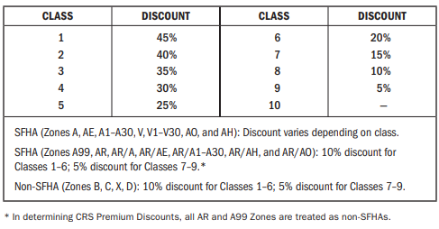 Source: FEMA
The CRS provides an incentive not just to start new mitigation programs but to keep them going. There are two requirements that “encourage” a community to implement flood mitigation activities. Once the parish has obtained a CRS rating and is a participant, the parish will receive CRS credit for this plan when it is adopted. To retain the credit, the parish must submit an evaluation report on progress toward implementing this plan to FEMA by October 1 of each year. That report must be made available to the media and the public. Second, the parish must annually recertify to FEMA that it is continuing to implement its CRS credited activities. Failure to maintain the same level of involvement in flood protection can result in a loss of CRS credit points and a resulting increase in flood insurance rates to residents.
In 2011[2], the National Flood Insurance Program (NFIP) completed a comprehensive review of the Community Rating System (CRS) that resulted in the release of a new CRS Coordinator’s Manual. The changes to the 2013 CRS Coordinator’s Manual are the result of a multi-year program evaluation that included input from a broad group of contributors to evaluate the CRS and refine the program to meet its stated goals. The changes helped to drive new achievements in the following six core flood loss reduction areas important to the NFIP: (1) reduce liabilities to the NFIP Fund; (2) improve disaster resiliency and sustainability of communities; (3) integrate a Whole Community approach to addressing emergency management; (4) promote natural and beneficial functions of floodplains; (5) increase understanding of risk, and; (6) strengthen adoption and enforcement of disaster-resistant building codes.
Since the revision of the 2013 Coordinator’s Manual, FEMA released the 2017 CRS Coordinator’s Manual, which continued the evolution of the CRS program and its mission to reward communities that prioritize mindful floodplain regulations. As with the 2013 manual, the changes made in the 2017 manual impact each CRS community differently. Some communities see an increase in the points they receive since points for certain activities have increased (e.g., Activity 420 Open Space Preservation). Other communities receive fewer points for specific activities (e.g., Activity 320 Map Information Service). It is likely that some communities with marginal CRS Class 9 programs have to identify new CRS credits in order to remain in the CRS class. Most notably, as it relates to this hazard mitigation plan, more credit was made available for Activity 410 Floodplain Mapping.
Typically, CRS communities do not request credit for all the activities they are currently implementing unless it would earn enough credit to advance the community to a higher CRS Class. A community that finds itself losing CRS credit with the 2017 manual could likely identify activities deserving credit they had not previously received. Due to the changes in both activities and CRS points, community CRS coordinators should speak with their ISO/CRS Specialist to understand how the 2017 manual will impact their community and when.
Inventory of Assets for the Entire Parish
As part of the Risk Assessment, the planning team identified essential facilities throughout the parish. This is done to quantify potential damage to structures and to qualify potential disruption to critical lifelines. For more information on how FEMA defines critical lifelines, please see the footnote below.[3]
The table below provides the total estimated value for each type of structure by occupancy.
Table 57: Estimated Total of Potential Losses throughout Orleans Parish
| Occupancy |
City of New Orleans |
Sewerage and Water Board of New Orleans |
New Orleans Redevelopment Authority |
| Agricultural |
$40,971,000 |
|
|
| Commercial |
$7,422,191,000 |
|
|
| Government |
$560,202,000 |
$2,406,400,000 |
$1,329,967 |
| Industrial |
$1,088,619,000 |
|
|
| Religion |
$1,246,887,000 |
|
|
| Residential |
$33,606,098,000 |
|
|
| Education |
$1,123,532,000 |
|
|
| Total |
$45,088,500,000 |
|
|
Source: HAZUS
Essential Facilities of the Parish
A full list of critical facilities is included in appendix C.
Figure 55: Fire and Rescue & Law Enforcement and Correction Facilities in Orleans Parish
Source: City of New Orleans
Figure 56: Government Facilities in Orleans Parish
Source: City of New Orleans
Figure 57: Educational Facilities in Orleans Parish
Source: City of New Orleans
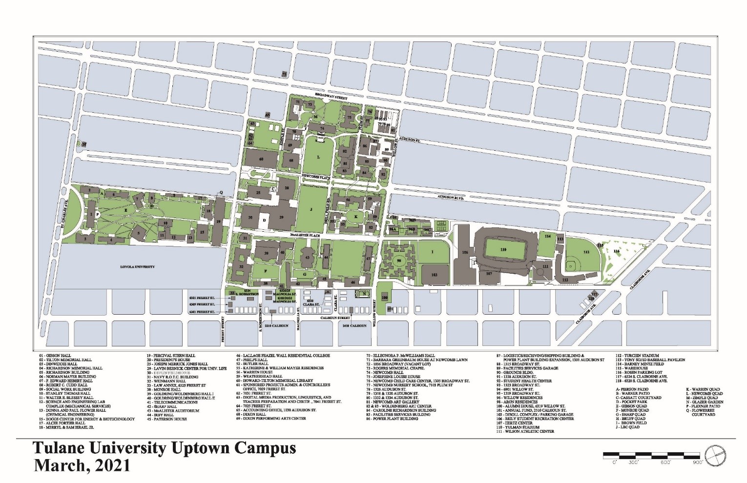
Tulane University Facilities
Below is an excerpt of the Tulane University: Disaster Resistant University Hazard Mitigation Plan (2011):
The Uptown Campus area has an extensive history of flood events – almost twenty (20) have been recorded in the Parish since 1996, with several of those impacting the campus. (The Uptown Campus often and regularly experiences these flooding events. Because it is the largest and most populated campus, flooding at the Uptown Campus is of the utmost concern for Tulane University.
There are approximately thirty (30) Tulane facilities located in the Special Flood Hazard Area (SFHA) at the Uptown Campus. Ten (10) of these facilities are used for housing and have been assigned a Level 1 criticality ranking:
- Irby House
- Patterson House
- Phelps House
- Butler House
- Warren House
- Wall Residential College
- William Mayer Residences
- Willow Residences
- Aron Residences
- Weatherhead Hall
Additionally, the Tulane Emergency Medical Services office (Level 1) on Claiborne Avenue is located in the SFHA at the Uptown Campus.
The following maps show Tulane’s campus and the Preliminary DFIRM Special Flood Zone Area with building locations on campus. A majority of campus buildings are not within the 100 year Special Flood Hazard Area with the exception of the building located at 5324 S. Claiborne Ave.
Figure 59: Special Flood Hazard Area for Uptown Campus Facilities
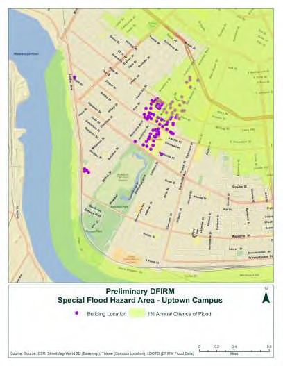
Source: ESRI; Tulane; and LDoTD
New Orleans Floodplain Management Regulations and Enforcement
Introduction
New Orleans’ floodplain management is the operation of a community program of corrective and preventative measures for reducing flood damage. These measures take various forms and generally include requirements for zoning, subdivision or building, and special-purpose floodplain ordinances.
The recent City of New Orleans Capability Assessment canvassed relevant City of New Orleans jurisdictions (offices, departments, and commissions) on two questions.
- Are the City’s floodplain management measures effective in reducing flood hazard impacts; and
- Are the City’s floodplain management measures adequately administered and enforced?
New Orleans’ floodplain management regulations and enforcement are embodied in two divisions:
- Building Codes, Permitting, and Inspections; and
- Land use planning and ordinances.
Building Codes, Permitting, and Inspections
At the time the 2015 HMP was adopted, construction in the City of New Orleans was regulated in accordance with the 2012 edition of the International Building Code (IBC), International Residential Code (IRC), International Mechanical Code (IMC), and International Fuel Gas Code; and electrical work was governed by the 2011 National Electrical Code (NEC). Effective February 1, 2018, the city of New Orleans adopted the following updated building codes: IBC 2015, IRC 2015, IMC 2015, and NEC 2014. The 2015 edition of the International Codes (I-Codes) contains provisions that meet or exceed the minimum flood-resistant design and construction requirements of the National Flood Insurance Program (NFIP) for buildings and structures.
The consensus of the Capability Assessment respondents is that the current New Orleans Building Codes are effective in reducing flood hazard impacts; and that the current New Orleans Building Codes are adequately administered and enforced.
The New Orleans Building Code also has a substantial damage provision that requires properties to be brought up to code and impacts vulnerability to a number of hazards. It also can trigger making ICC funds available for flood mitigation.
The consensus of the Capability Assessment respondents is that site plan review requirements under the current New Orleans Building Codes are effective in reducing flood hazard impacts; and that the current site plan review requirements are adequately administered and enforced.
Building Code Effectiveness Grading Schedule
Data is unavailable as to New Orleans’ participation in the Building Code Effectiveness Grading Schedule (BCEGS). BCEGS (performed by Insurance Services Office, ISO) assesses the building codes in effect in a community and how the community enforces its building codes, with special emphasis on mitigation of losses from natural hazards. ISO is an organization that collects statistical data, promulgates rating information, develops standard policy forms, and files information with state regulators on behalf of insurance companies that purchase its services. The participant communities receive a rating grade. The BCEGS score for a community can have implications for its Community Rating System score.
The consensus of Capability Assessment respondents is that the BCEGS is not effective in reducing flood hazard impacts in New Orleans, suggesting that the City does not participate, or there are technical or other issues with its participation or grade.
Land Use Planning and Ordinances
CNO Land-use ordinances fall under four general headings:
- the Comprehensive Zoning Ordinance;
- the Subdivision Ordinance;
- the Floodplain Ordinance; and
- Naturel Hazard -Specific Ordinances, of which the Stormwater Ordinance is the most relevant to floodplain management.
The Comprehensive Zoning Ordinance (CZO)
In 2015, the New Orleans City Council adopted a new Comprehensive Zoning Ordinance (CZO). The full CZO is intended to give legal force to the New Orleans Master Plan, which was adopted in 2010. Article 23 of the CZO, Landscape Stormwater Management and Screening, sought to reduce urban runoff and mitigate the effect of new development, redevelopment, or infill development on the existing drainage system. The Article required a landscape and stormwater management plan for most new development (excluding some residential property) and submission of the plan prior to receiving a permit. Article 23 included several elements that required or strongly encouraged the preservation of permeable surfaces and green infrastructure practices to manage stormwater. Article 23 also required Best Management Practices (BMPs) to minimize runoff, increase infiltration, recharge groundwater, and improve water quality. In March of 2018, The City of New Orleans officially replaced Article 23 of the Comprehensive Zoning Ordinance (CZO) with a new unified Stormwater Code located within Chapter 1, Section 121 of the Building Code (discussed below). The new code contains requirements to protect the City’s drainage system during construction, as well as post-construction stormwater management requirements for some projects.
Article 7 of the CZO addresses the protection and preservation of existing natural areas, such as wetlands, to provide stormwater protection and reduce flooding risk.
The consensus of the Capability Assessment respondents is that the provisions of the CZO are effective in reducing flood hazard impacts; and that the CZO is adequately administered and enforced.
Subdivision Ordinance
The City Council adopted the current CNO Subdivision Regulations (Subdivision Ordinance) in May 1999. The regulations contain various provisions to minimize or eliminate flood to subdivision development and to regulate construction to above minimum base flood elevation (BFE) as indicated on the current FEMA Flood Insurance Rate Map (FIRM) for the subdivision.
The consensus of the Capability Assessment respondents is that the provisions of the Subdivision Ordinance are effective in reducing flood hazard impacts; and that the CZO is adequately administered and enforced. However, the City of New Orleans Planning Commission and City of New Orleans Project Delivery Unit are currently (June 2020) revising the 1999 Subdivision Ordinance.
Floodplain Ordinance
The City Council adopted the current CNO Floodplain Ordinance in May 2016, effective 1 June 2016. The ordinance established regulations and requirements for flood damage protection in compliance with the National Flood Insurance Program (NFIP) and the 2016 FIRM. All development in the city, whether constructing a new building, repairing a building substantially damaged by any cause, or substantially improving a building, is required to meet flood protection requirements under the ordinance. In order to provide a higher standard of property protection, all new construction and substantial improvements are required to build to either 3 ft above the highest adjacent curb or at 1ft above the FIRM-provided Base Flood Elevation, whichever is higher. This standard is similar to the ABFE regulations that had been in place for the previous 10 years. Special regulations also apply in Coastal Flood Hazard areas.
- Flood Insurance Rate Maps. As required for participation in the NFIP, the 2016 CNO Floodplain Ordinance adopted the FEMA FIRM dated 16 September 2016, subject to FEMA amendments. Some areas of the City formerly considered SFHAs were reclassified as non-SFHA zones in the 2016 FIRM, allowing properties in those areas reduced flood insurance premiums or to forego flood insurance altogether. In fact, the City has seen a decline in the number of properties carrying flood insurance since the adoption of the 2016 FIRM (although not a decline in the value of insurance in force). Some critics have considered this correlation of reduced numbers of properties carrying flood insurance with flood zone-reclassification to be less than optimal in terms of the City’s preparedness for flood hazards.
The consensus of the Capability Assessment respondents is that the provisions of the Floodplain Ordinance are effective in reducing flood hazard impacts; and that the CZO is adequately administered and enforced.
Stormwater Ordinance [Stormwater Code]
In March of 2018, CNO officially replaced Article 23 of the Comprehensive Zoning Ordinance (CZO) with a new unified Stormwater Code located within Chapter 1, Section 121 of the Building Code. The 2018 stormwater ordinance seeks to reduce urban runoff and mitigate the effect of new development and contains requirements to protect the City’s drainage system during construction, as well as post-construction stormwater management requirements for some projects. The current Stormwater code requires that all contractors working within the City of New Orleans must provide erosion and sediment control on sites where the ground is disturbed; and provide catch basin protection for any adjacent facilities. Further requirements apply to other onsite protections. These requirements apply to any new development or redevelopment, aside from residential properties with less than six (6) dwelling units, that has 5,000 square feet or more of impervious surface, or a total site area of one acre or more. The ordinance requires that the plan retain (or detain) and filter the first 1.25 inch of stormwater runoff during each rain event and limit the post-development runoff rate.
Most of the Capability Assessment respondents concur that the provisions of the Stormwater Code are effective in reducing flood hazard impacts; and that the CZO is adequately administered and enforced. However, one respondent felt that regulation on development impacts on existing City infrastructure needs to be strengthened still further. In addition, the dissenting respondent recommends the development of a more direct linkage between development and drainage system improvements, including the creation of a drainage impact fee (or stormwater user fee) that would directly fund drainage infrastructure improvement. Such fees have been proposed before but are have not been enacted as policy.
Acquisition of Land for Open Space and Public Recreation Uses
The Plan for the 21st Century, commonly referred to as the Master Plan, is CNO’s planning framework. The Master Plan was adopted in 2010, and the City engaged in a Plan amendment process from 2016 to 2018. In the Plan, acquisition of land for open space and public recreation uses is a recommended strategy for the goals of wetland preservation, maintenance of total parkland area, and increasing the area for parks and public recreation. To implement these strategies, the Master Plan recommends partnering with conservation organizations, earmarking proceeds from the sale of public land to park acquisition, and creation of a parks trust fund within the City’s Capital Projects Fund. A Parks trust fund could receive a percentage of funds set-aside from major park construction projects for maintenance, sale of any decommissioned parks, developer funds resulting from Community Benefits Agreements, or other donations for the park system. CNO has notable successes in obtaining areas for public use, such as the Lafitte Greenway and the Mirabeau Water Garden, both of which provide neighborhood resilience features and public recreational opportunities.
However, a majority of the Capability Assessment respondents do not find CNO’s efforts to acquire land for open space and public recreation effective in reducing flood hazard impacts. Data is lacking whether the cause of this ineffectiveness is lack of available funding for acquisition, the insufficient scale of land acquisitions for effective impact, lack of political or institutional commitment to acquisition and resilient development, or many other possible factors. One Capability Assessment respondent raised concern for equity of benefits from the acquisition of land for open space and public recreation. Benefits of specific open spaces for public use are inherently not spread across the whole city; some neighborhoods already enjoy greater resilience advantages and access to recreation than do others. Additional public involvement and stakeholder coordination in consideration of the issue of land acquisition for open space and public recreation uses is recommended.
Summary Conclusion
The offices, departments, and commissions responding to the floodplain management regulations and enforcement survey contained in the City of New Orleans Capabilities Assessment addressed two questions:
- Are the City’s floodplain management measures effective in reducing flood hazard impacts; and
- Are the City’s floodplain management measures adequately administered and enforced?
The general consensus of the Capability Assessment respondents is that in most (but not all) aspects, the provisions of the Floodplain Ordinance are effective in reducing flood hazard impacts; and that floodplain management regulations are adequately administered and enforced.
Respondents identified several salient areas where the regulations and enforcement might be significantly improved. One was in the structure of the stormwater ordinance, which a respondent felt could be made even more stringent to further reduce impacts of development upon drainage infrastructure, and a recognition that the politically sensitive issue of a drainage impact fee (or stormwater user fee) that would directly fund drainage infrastructure improvement should remain a proposal for consideration. Another finding was a consensus that Acquisition of Land for Open Space and Public Recreation Uses is not effective in reducing flood hazard impacts, although this can be interpreted as not due to technical problems with resilience features so much as to a political process that has not prioritized land acquisition or operated with appropriate sensitivity to equity issues. This last consideration may be addressed by increased public involvement in the planning process.
There was also consensus among Capability Assessment respondents that at present, the Building Code Effectiveness Grading Schedule (BECGS) is not effective in reducing flood hazard impacts in New Orleans. The Capability Assessment states the CNO Department of Safety and Permits is currently working on BCEGS participation for the City.
[1] http://www.fema.gov/media-library-data/20130726-2128-31471-9581/ks_ky_la_crs_may_2012_508.zip
[2] FEMA Community Rating System https://www.fema.gov/national-flood-insurance-program-community-rating-system
[3] https://www.fema.gov/lifelines
Leave a Comment