Location and Extent of Coastal Erosion
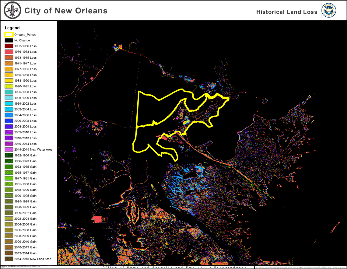
The USGS has identified areas of coastal erosion that have occurred between 1932 and 2015 in southeastern Louisiana (Figure 29). The City of New Orleans is susceptible to Coastal Erosion in the areas outside of the levees, i.e., the eastern and southern portions of the parish. Land loss is driven by complex interactions between factors including, but not limited to, sediment supply, wetland plant health, water quality, global mean sea level change, and subsidence.
Figure 29: Geomorphic Classification of Coastal Land Loss between 1932 and 1990 in Southeastern Louisiana

Source: USGS – Coastal Erosion and Wetland Change in Louisiana
Severity of the Coastal Erosion hazard
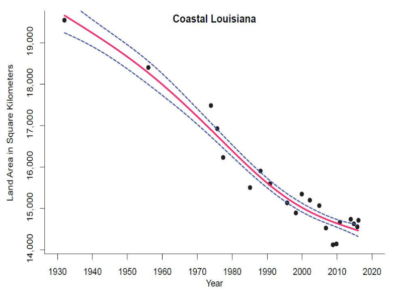
Louisiana has the highest rate of wetlands loss in the Country, with the State accounting for 80 percent of the nation’s coastal wetland loss.[1] In total, the USGS estimates that Louisiana has lost approximately 1,900 square miles of its coast since 1932.
Within the past 100 years, Louisiana's barrier islands have decreased in area by more than 40 percent, and some islands have lost more than 75 percent of their land area. If these loss rates continue, several of the barriers are expected to erode entirely within the next three decades. Their disappearance will contribute to further loss and deterioration of wetlands and back-barrier estuaries and increase the risk to infrastructure.
On April 19, 2017, Governor John Bel Edwards declared a state of emergency for the Louisiana coast due to the effects of coastal land loss. “The emergency proclamation will be sent to President Donald Trump and members of Congress as a necessary means of raising the national profile of this crisis and expediting priority restoration projects with the level of urgency those projects require.”[2] The state’s Master Plan, administered by the Coastal Protection and Restoration Authority, is the primary vehicle for addressing coastal land loss.
[1] Ocean Commotion: Fast Facts | Louisiana Sea Grant. (n.d.). Retrieved December 17, 2020
[2] Gov. Edwards Declares State of Emergency for Louisiana Coast | Office of Governor John Bel Edwards. (n.d.). Retrieved December 17, 2020
Previous Occurrences of Coastal Erosion
Although there are specific areas of more severe coastal erosion along the Louisiana coastline, this is an ongoing process that impacts the entire coastal region of Louisiana. The amount of coastal erosion varies from year to year (Figure 30).
Hurricanes Katrina and Rita resulted in the destruction of more than 217 square miles of coastal wetlands during their landfalls.[1] The loss attributed to these storms exceeds the wetland losses that had been projected to occur in the entire state over the next 20 years. In addition, Hurricane Katrina destroyed or substantially damaged about one-half of the State’s barrier islands along the Gulf of Mexico.[2]
[1] Recalling the Storm, Preparing for the Future. (n.d.). Retrieved December 17, 2020
Figure 30: Change in Louisiana’s Coastal Wetland Areas, 1932 – 2016

Source: United States Geological Survey (USGS) - Coastal Erosion and Wetland Change in Louisiana
Hazard Impacts
Impact on Life and Property
Coastal erosion does not directly impact HANO, NORA, or Tulane University, because the assets and population of these entities are entirely contained within the levee protection system, which is engineered to prevent erosion. The City of New Orleans and SWBNO both have assets including roads, utility infrastructure, and public safety facilities that may be impacted by coastal erosion.
The slow movement and advancement of coastal erosion are not in itself life-threatening; however, the continued loss of wetlands along the Louisiana coastline can have a direct effect on the severity of hurricanes and tropical storms. The wetlands act as a buffer to reduce hurricane wind speeds and storm surge heights, thus reducing the severity of these events. Without protection from coastal wetlands, areas such as New Orleans are at greater risk from major hurricane events.
Coastal erosion also has the potential to cause substantial property damage and negative impacts to the Louisiana economy. This includes threats to transportation assets, including U.S. 11, U.S. 90, the train tracks for Canadian Northern, Norfolk Southern, and CSX, which are outside the levee, and in areas of high erosion and exposure to coastal storms. If losses continue at the current rate, coastal erosion has the potential to have direct implications on the nation’s energy supplies, economic security, and environmental integrity. Numerous studies have been conducted to identify the major contributing factors that have caused such extensive land loss in southeastern Louisiana. Most studies agree that land loss and the degradation of the coastal ecosystem are the results of both natural and human-induced factors, producing conditions where wetland vegetation can no longer survive or is directly extracted, and wetlands are lost.
Although New Orleans is not at immediate physical risk from coastal erosion, the loss of coastal wetlands represents a severe vulnerability for nearly all facilities, populations, and operations in the area. There are numerous studies that include projections of potential losses from storm surges under various future coastal erosion scenarios (please see the Storm Surge Flooding hazard profile).
In the next several decades, sea-level rise has the potential to cause further coastal land loss in Louisiana. Absent significant intervention, 2,250 square miles could be lost over the next 50 years.[1] This is a conservative estimate since it presumes a continuation of what has been observed over the past 50 years, without factoring in the acceleration of sea-level rise from potential climate change. Over the long term, the loss of coastal landmasses that provide some protection for the City of New Orleans from hurricanes is vitally important. The loss of this critical natural barrier will have a tremendous impact on all of New Orleans and the surrounding parishes by making them more vulnerable, especially to powerful hurricanes.
An LSU report, Regional Impacts of Coastal Land Loss and Louisiana’s Opportunity for Growth, estimates that infrastructure replacement costs and business disruptions in the New Orleans Region (including Jefferson, Orleans, Plaquemines, St. Bernard, St. Charles, St. James, St. John the Baptist, and St. Tammany parishes) could total $1.7 billion due to land loss over the next 50 years if no action is taken to protect or restore the state’s coast.[2]
Assuming an eastern-track storm (similar to Hurricane Katrina’s path), the report estimates that storm surge would intensify due to the loss of coastal land, increasing pressure on the levee system and the chances of widespread flooding within the levee system and resulting in $130 billion in replacement costs and $26 billion in business disruption.
Additionally, the report estimates that physical damage to the New Orleans region due to the impacts of coastal erosion could reach $1.3 billion in 25 years and $1.7 billion in 50 years. This includes replacement costs for businesses, residences, and infrastructure. In addition to physical damage, over 9,000 jobs and $568 million in wages could be lost within 50 years.
[1] Coastal Protection and Restoration Authority of Louisiana. 2017. Louisiana’s Comprehensive Master Plan for a Sustainable Coast: Committed to Our Coast. State of Louisiana.
[2] Barnes, Stephen R. and Virgets, Stephanie. 2017. Regional Impacts of Coastal Land Loss and Louisiana’s Opportunity for Growth. LSU E.J. Ourso College of Business Economics & Policy Research Group. Available:
Vulnerability
There is a 100% statistical probability that additional erosion will occur in the future. The models developed by the Coastal Protection and Restoration Authority demonstrate that projected land loss over the next 10 years will primarily impact New Orleans East, making these neighborhoods more vulnerable to storm surge, other flooding events and negatively impacting existing homes and businesses. Figure 32 identifies the projected land loss (shown in red) in Orleans Parish; significant erosion may occur in or near the far eastern and southern part of East New Orleans. To model future land loss, CPRA used regionally adjusted values for the Gulf of Mexico to represent a range of plausible future conditions. These scenarios represent accelerating sea level rise rates above the historic linear rate. The 2015-2065 rates result in mean relative sea level rise (RSLR) of 0.46' (low scenario) and 2.72' (high scenario).[i] For a list of vulnerable critical facilities please see Appendix C.
[i] Pahl, J. (2017). 2017 Coastal Master Plan: Attachment C-2 Eustatic Sea Level Rise. Version Final. (p. 23). Baton Rouge, LA: Coastal Protection and Restoration Authority.
Figure 31: Projected Land Loss and Land Gain in Year 10, Future Without Action
Source: Coastal Protection and Restoration Authority 2017, City of New Orleans
The same model estimates that over the next 50 years, additional land will be lost along Lake Pontchartrain and the coastal wetlands outside of the levee system.
Figure 32: Land Loss and Land Gain, Year 50 Future Without Action
Source: Coastal Protection and Restoration Authority 2017, City of New Orleans
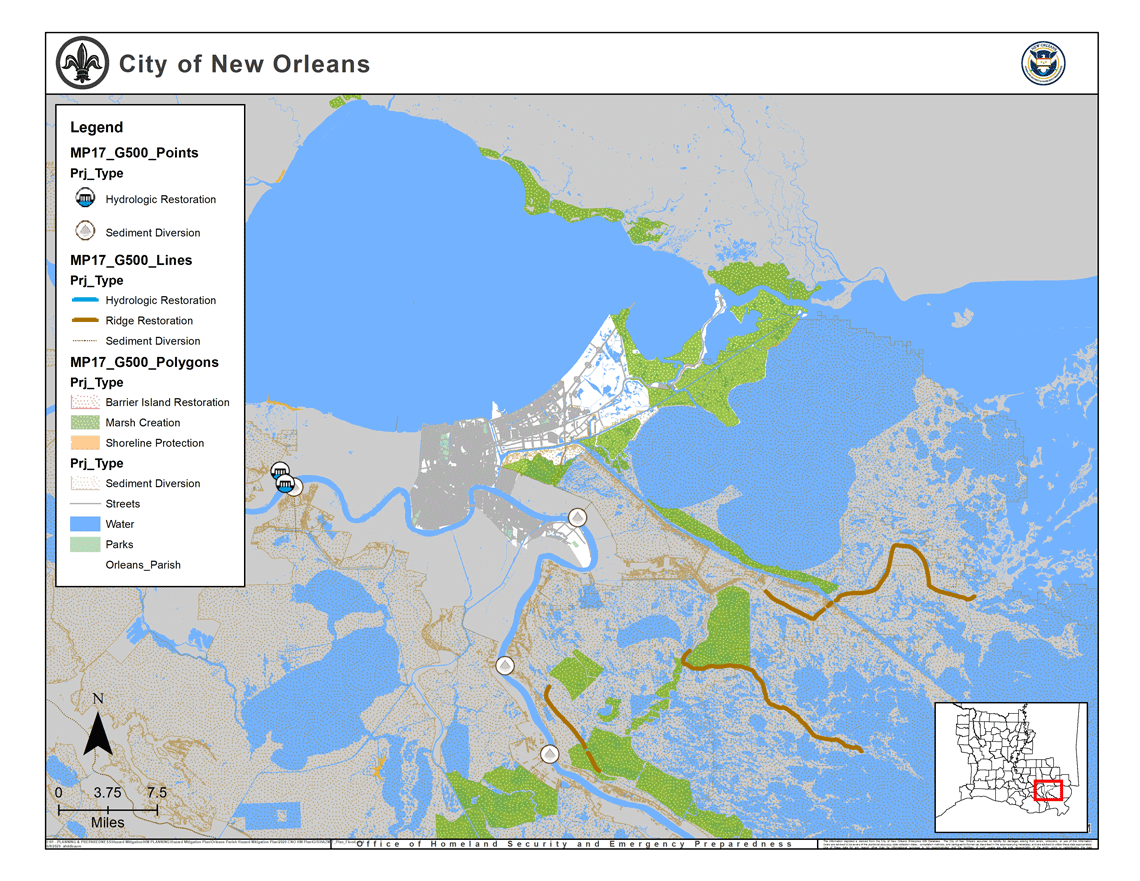
The Louisiana Coastal Preservation and Restoration Authority (CPRA) has a master plan that includes a suite of projects intended to offset the most severe impacts of coastal erosion (Figure 33) . The goal of these projects is to fortify marshlands and help rebuild the coast and protect the communities of coastal Louisiana. However, there is uncertainty as to what the future holds for these projects and what their broader impacts might be for the New Orleans region. The Mitigation Strategy identifies actions related to some of the Coastal Master Plan projects that would have major impacts on New Orleans. The work of the Coastal Protection and Restoration Authority explains coastal erosion in detail in the Coastal Master Plan and other reports found at the CPRA’s website.
Figure 33: Wetland Restoration Projects including Louisiana’s Coastal Master Plan
 Source: Coastal Protection and Restoration Authority 2017, City of New Orleans