Location and Extent of the Storm Surge Hazard
The storm surge hazard associated with hurricanes and other severe storms is responsible for most coastal flooding along the Louisiana Gulf Coast. Storm surge in New Orleans is primarily the result of hurricanes that approach land from the Gulf of Mexico. The effects of storm surge can be felt in the Parish from hurricanes that make landfall as far away as Texas, Mississippi, or Alabama. The extent of the storm surge hazard covers the entire planning area. It is made worse in some areas based on such factors as elevation and proximity to flood sources (which are, in turn, related to potential levee failures). The storm surge threat in New Orleans has increased over the past 150 years due to a variety of factors such as coastal erosion, loss of wetlands, sea-level rise, and the construction of canals for navigation and drainage.
New Orleans is protected from storm surge by a system of federal levees known as the Hurricane Damage Risk Reduction System (HSDRRS) (Figure 19). The levee system was rebuilt by USACE in the years following Hurricane Katrina. Levee operations and maintenance are the responsibility of the Southeastern Louisiana Flood Authority-East and West, which were created by the State Legislature in 2006 to coordinate levee maintenance regionally. The levee system is designed to provide protection from storm surge up to the 100-year flood level.
Figure 19: New Orleans Hurricane Risk Reduction System, with Locations of Levee Failures caused by Hurricane Katrina in 2005
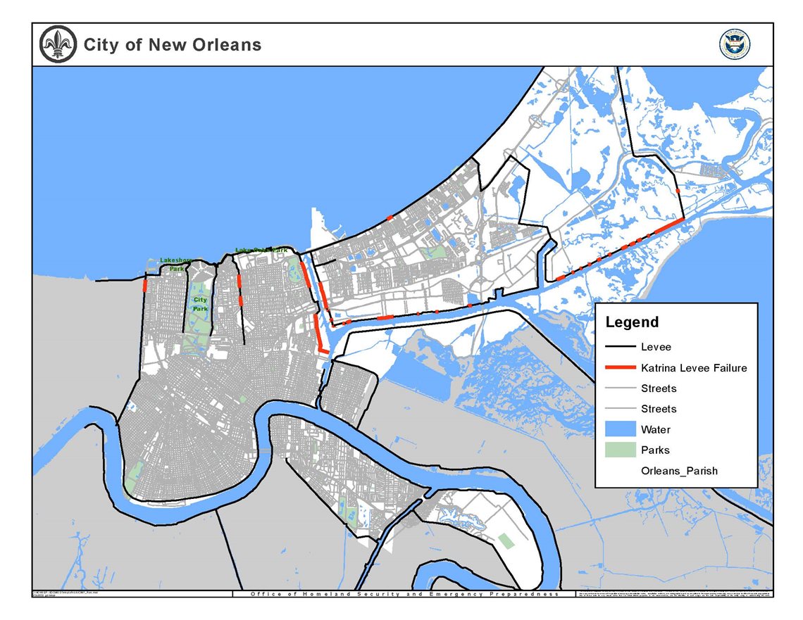
Source: City of New Orleans
Severity of the Storm Surge Hazard
In coastal areas such as southern Louisiana, storm surge is the most dangerous aspect of hurricanes, although the wind is a very significant hazard as well. Storm surge causes nine out of every ten hurricane-related deaths.[1] The severity of storm surge is determined by a variety of factors such as the path of a hurricane, wind speeds, shape of the coastline, and the forward speed. The forward motion of a storm complements the counterclockwise rotation of the wind field, which usually results in the highest surges from hurricanes occurring on the right-front (northeast) quadrant of the storm’s track. Table 19 identifies the factors that can influence the severity of storm surge.
Table 19: Factors that Influence the Severity of Storm Surge
| Factor |
Effect |
| Wind Velocity |
The higher the wind velocity, the greater the damage |
| Storm Surge Height |
The higher the storm surge the farther inland the inundation area and the greater the damage |
| Coastal Shape |
Concave shoreline sections sustain more damage because the water is driven into a confined area by the advancing storm, thus increasing storm surge height and storm surge flooding |
| Storm Center Velocity |
The slower the storm moves, the greater potential for damage along the immediate coastline. The worst possible situation is a storm that stalls along a coast, through several high tides. |
| Nature of Coast |
Damage is most severe on low-lying island barrier shorelines because they are easily over washed by wave action. |
| Previous Storm Damage |
A coast weakened by even a minor previous storm will be subject to greater damage in a subsequent storm. |
| Storm Size |
The size of a storm and extent of hurricane force winds can influence the area of coastline impacted by storm surge. Larger hurricanes with expansive hurricane-force winds can create significant surge over a large section of coastline. |
| Central Pressure |
The lower a hurricane’s central pressure the greater the wind speeds and potential for stronger storm surge. |
| Storm Track (or Path) |
The right-front (northeast) quadrant of the storm track typically experiences the most severe surge as a hurricane eye makes landfall. |
| Forward Speed |
The forward speed of a hurricane can influence the peak height and how far inland a surge will reach. |
| Human Activity |
With increased development, property damage increases, and more floating debris becomes available to knock down other structures |
Source: NOAA National Hurricane Center, New Scientist Magazine, April 2009
Previous Occurrences of the Storm Surge Hazard
As part of the plan update, the planning team examined various sources to identify past storm surge events that have impacted New Orleans. As indicated elsewhere in this section, one source for identifying past storm surge events is NOAA’s NCEI database. The NCEI indicates eleven storm surge events impacted New Orleans between 1950 and 2019. Table 20 summarizes the storm surge events reported by the NCEI that have impacted southern Louisiana and New Orleans between 1998 and 2019. The events are summarized following Table.
Table 20: Storm Surge Events, Orleans Parish, 1998-2019
| Date |
Type |
Property Damage |
| 2/15/1998 |
Storm Surge/Tide |
$0 |
| 9/12/1998 |
Storm Surge/Tide |
$0 |
| 6/30/2003 |
Storm Surge/Tide |
$100,000 |
| 9/15/2004 |
Storm Surge/Tide |
$400,000 |
| 10/9/2004 |
Storm Surge/Tide |
$10,000 |
| 7/5/2005 |
Storm Surge/Tide |
$250,000 |
| 8/29/2005 |
Storm Surge/Tide |
$17,900,000,000 |
| 9/23/2005 |
Storm Surge/Tide |
$4,320,000 |
| 9/1/2008 |
Storm Surge/Tide |
$750,000 |
| 9/11/2008 |
Storm Surge/Tide |
$0 |
| 9/2/2011 |
Storm Surge/Tide |
$15,000 |
| 8/28/2012 |
Storm Surge/Tide |
$62,500,000 |
| 6/21/2017 |
Storm Surge/Tide |
$0 |
| 10/7/2017 |
Storm Surge/Tide |
$0 |
| 7/11/2019 |
Storm Surge/Tide |
$0 |
| Totals |
|
$17,968,345,000 |
Source: NOAA National Centers for Environmental Information
Hurricane Katrina
Hurricane Katrina made landfall in September of 2005 as a powerful Category 3 hurricane that had a devastating impact on the New Orleans area and the entire Gulf Coast region. Hurricane-force winds from Katrina produced the greatest recorded storm surge in the United States. Data collected by FEMA shortly after the event indicated a storm surge of 15 to 19 feet occurred in eastern New Orleans, St. Bernard Parish, and Plaquemines Parish. At the same time, the surge was 10 to 14 feet in western New Orleans along the southern shores of Lake Pontchartrain. Farther west, observations indicate a storm surge of 5 to 10 feet along the shores of western Lake Pontchartrain.
The storm surge on August 29 severely strained the levee system in the New Orleans area. Several of the levees and floodwalls were overtopped and/or breached at different times on the day of landfall. Most of the floodwall and levee breaches were due to erosion on the backside caused by overtopping. The surge overtopped large sections of the levees east of New Orleans, in Orleans Parish and St. Bernard Parish, and it also pushed water up the Intracoastal Waterway and into the Industrial Canal. The water rose in Lake Pontchartrain strained the floodwalls along the canals adjacent to its southern shore, including the 17th Street Canal and the London Avenue Canal.
The volume of water entering the City when the levees failed immediately overwhelmed the 23 major pump stations throughout New Orleans, which are designed to remove surface runoff during rain events. The inundation of the city flooded an estimated 147,000 residential homes. As the floodwaters rose, thousands of residents who were unable to evacuate became trapped, many on rooftops and some in their attics. Figure 20 below identifies the location and flood depths throughout the City on September 2, 2005. Within about 24 hours of Katrina’s landfall, about 80 percent of the City of New Orleans flooded to varying depths up to about 20 feet.
Figure 20: City of New Orleans: Estimated Water Depths on September 2, 2005
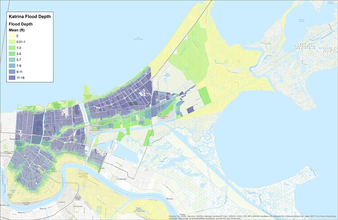 Source: USGS 2002 LiDAR Data
The consequences of the flooding were catastrophic for the City of New Orleans. Large developed areas were inundated with floodwater for extended periods before repairs could be made to the levees and pump stations, and the water drained out of the City. The pumps were brought back online on October 11, 2005, 43 days after Hurricane Katrina made landfall.
After Katrina, the NHC used the SLOSH (sea, lake, and overland surges from hurricanes) model to develop a computerized model of the storm surge. The SLOSH model is used to estimate storm surge heights and winds by considering the pressure, size, forward speed, track, and winds. Figure 21 below shows the storm surge estimated by the NHC.
Figure 21: Storm Surge for Hurricane Katrina
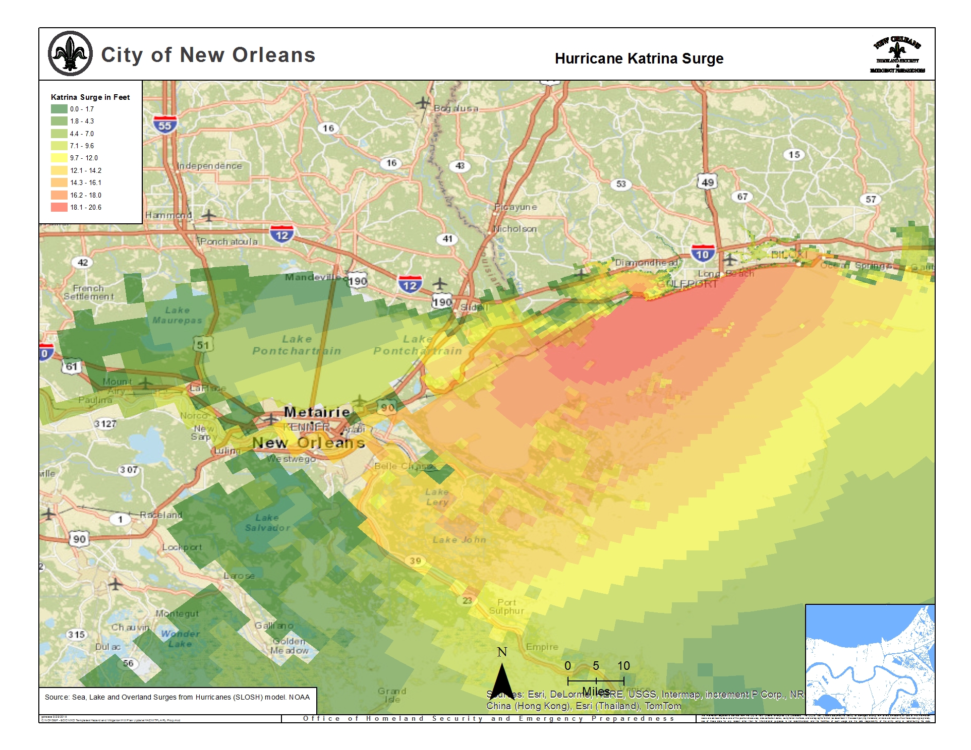
Source: NOAA National Hurricane Center
Before Katrina, SLOSH models developed for the Louisiana coastline estimated storm surge flooding inland up to 18 feet above sea level. The damages caused by Hurricane Katrina demonstrate that storm surge-related flooding can reach depths of up to 30 feet above sea level, with the ability to reach either the north shore of Lake Pontchartrain, just north of New Orleans, or the south shore in Jefferson and Orleans Parishes.
The most detailed current estimate of currently storm surge risk is based upon a recent study using the SLOSH model. Utilizing the Maximum of Maximums (MoM) for a Category 3 storm, which compiles the worst-case inundations based upon hundreds of possible tracks, the scenario shows an overtopping of the levees and significant inundation throughout the city can result from a Category 3 storm.
Figure 22: New Orleans Sea, Lake, and Overland Surges from Hurricanes (SLOSH) Model
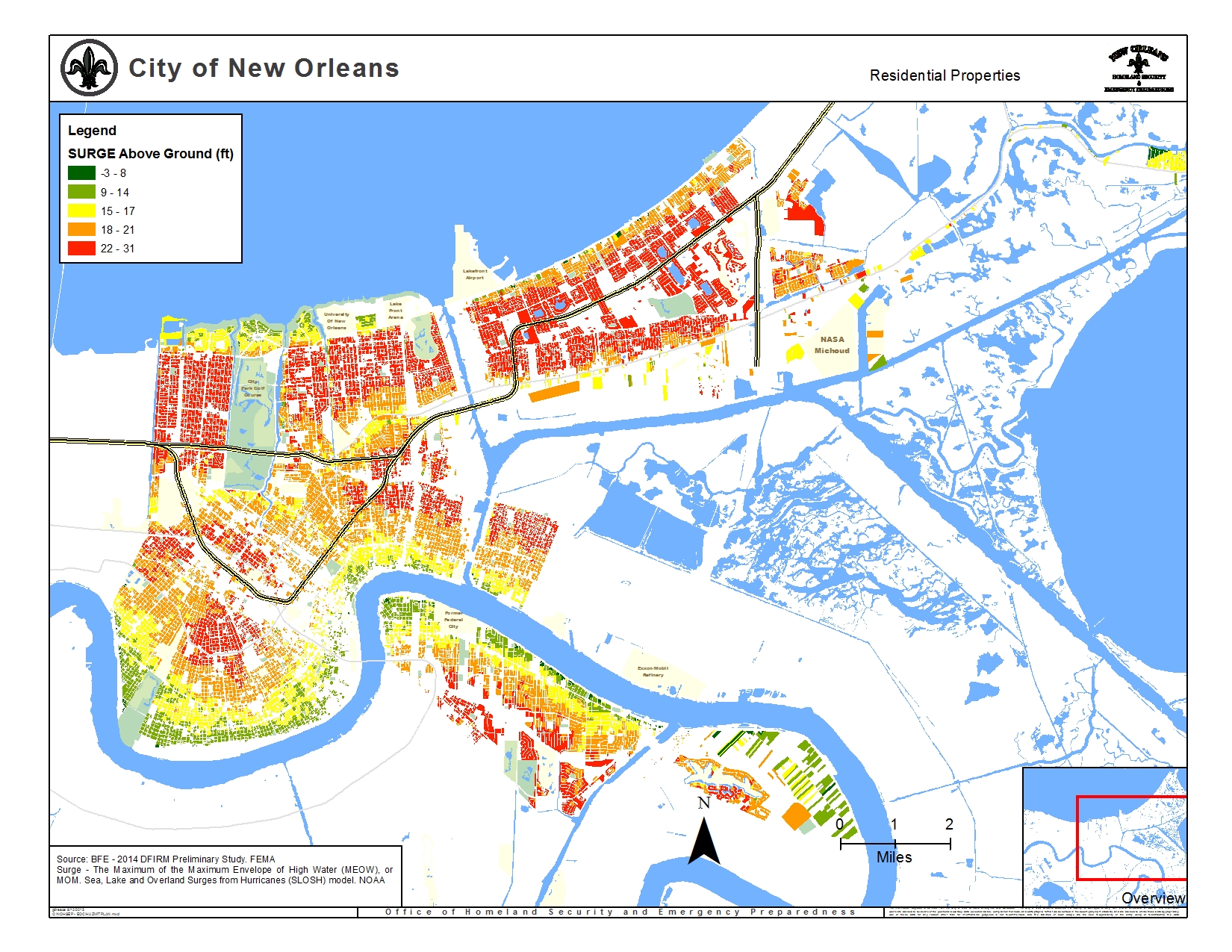
Source: FEMA HAZUS Data, City of New Orleans
Hazard Impacts
Impact on Life and Property
Storm surge is considered one of the most deadly and destructive components of a hurricane. As described in more detail below in the Occurrences of the Storm Surge Hazard, numerous past storm surge events associated with major Hurricanes (Category 3 or stronger) have caused considerable, sometimes catastrophic, damage to portions of New Orleans. These surge events have also been accompanied by considerable injuries and loss of life within the planning area.
The impact of storm surge can include the destruction of community assets such as museums and historic landmarks, along with the disruption of essential services, business operations, and cultural events, causing significant impacts on the social fabric of the city and its people.
Although the available data limit the ability to identify figures relating to the specific causes of death, it is widely accepted based on a review of numerous reports and studies that the majority of deaths associated with these events were the result of storm surge.
Future Probability
The threat of flooding caused by storm surge will continue to be a significant problem for New Orleans. Over the next several decades, a number of factors related to storm surge hazards can be expected to change the risk of flooding in New Orleans. These include increases in the relative sea level of the region due to geological subsidence and global sea-level rise, loss of coastal wetlands, and potential increases in hurricane activity in the Gulf of Mexico[2].
The Louisiana Coastal Preservation and Restoration Authority and others have done extensive work to forecast the extent and severity of future storm surge flooding. While the predictions vary and are influenced by uncertain factors including implementation of coastal restoration projects and global climate change, the data clearly show increasing risk from storm surge in the future (Figures 23-26).
Vulnerability
Based on the past 25 years (1994-2019) of NOAA data, the annual probability that New Orleans will experience flooding due to storm surge is 100%. Due to its proximity to the Gulf Coast, in conjunction with ongoing coastal land loss and the likely impacts of climate change, New Orleans is especially vulnerable to storm surge flooding. Areas outside the levee protection system generally have a higher vulnerability, although even areas within the HSDDRS system could be severely impacted by storm surge conditions that exceed the design of the levee system. For a list of vulnerable critical facilities please see Appendix C.
Figure 23: Flood Depths During a 100-Year Storm Surge Event
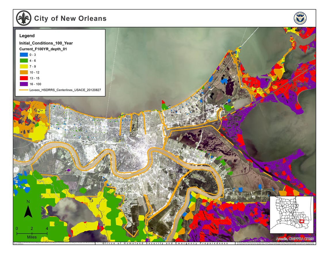 Source: Coastal Protection and Restoration Authority (CPRA), City of New Orleans
Figure 24: Flood Depths During a 500-Year Storm Surge Event
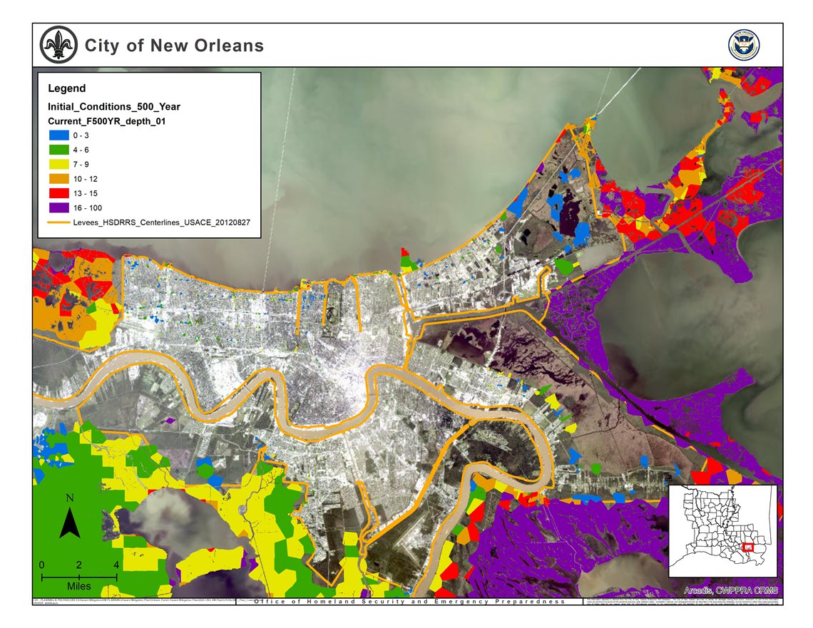 Source: Coastal Protection and Restoration Authority (CPRA), City of New Orleans
Figure 25: 100-year Storm Surge Flood Depths, 50 years in the Future Without Implementation of the Coastal Master Plan, under a “Low” Climate Scenario
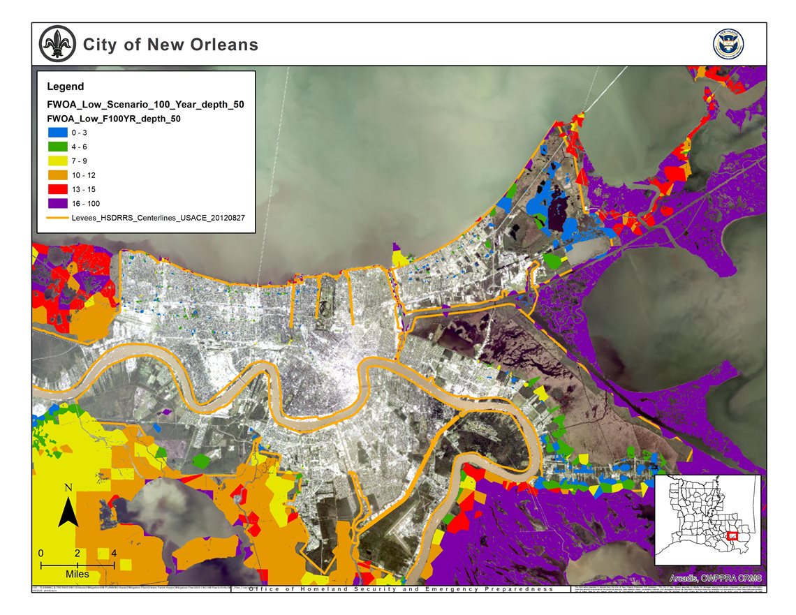 Source: Coastal Protection and Restoration Authority (CPRA), City of New Orleans
Figure 26: 100-year Storm Surge Flood Depths, 50 years in the Future Without Implementation of the Coastal Master Plan, under a “High” Climate Scenario
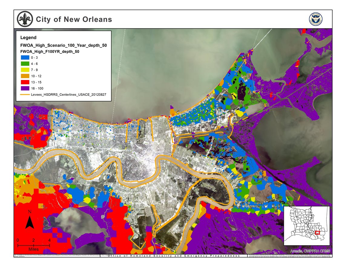
Source: Coastal Protection and Restoration Authority (CPRA), City of New Orleans